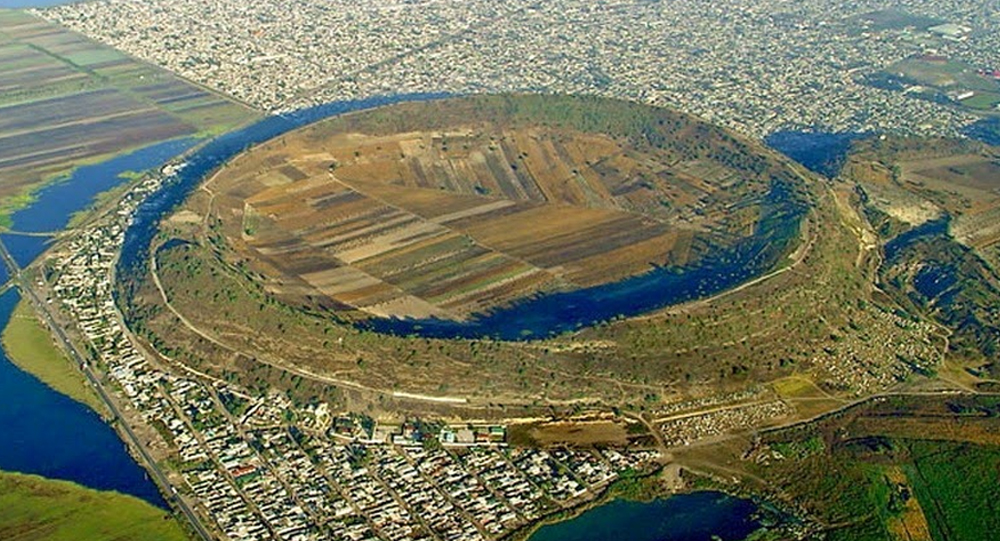
Xico’s story begins thousands of years ago as part of the Chichinautzin volcanic field south of Mexico City. The area known as Cerro de Xico (Hill of Xico) is actually a volcanic tuff ring crater, formed through repeated phreatomagmatic eruptions. These eruptions occur when rising magma interacts explosively with groundwater, creating broad, circular craters with steep rims.
Rather than a meteor impact, which some might assume due to its shape, geological studies confirm the crater’s volcanic origin. This ancient volcanic activity shaped much of the surrounding basin, influencing hydrology and soil at the regional level.
The eruption ejected large amounts of ash and debris, eventually cooling to form volcanic rock that remains visible in the crater walls today. Formation of Xico’s crater coincided with major volcanic events that also created other lakes and landforms within the Mexico Basin.
From Crater to Lake
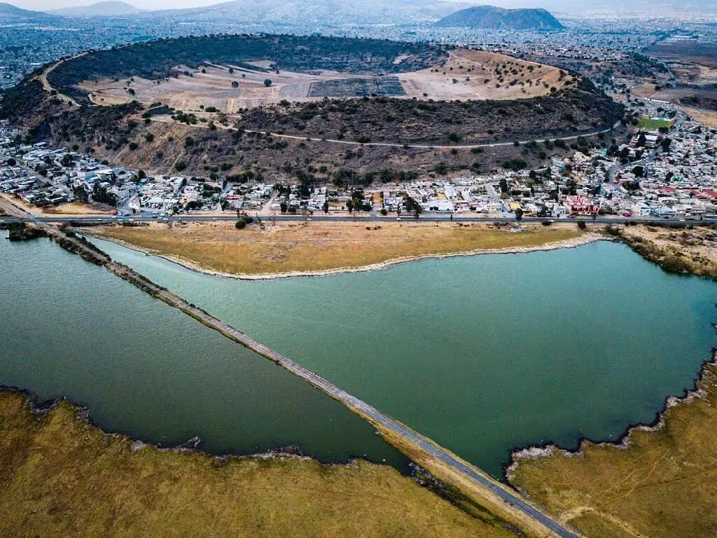
Following volcanic dormancy and regional tectonic shifts, the Xico crater gradually filled with water, becoming part of the larger Lake Chalco system. Lake Chalco, along with Lakes Texcoco and Xochimilco, was formed when volcanic barriers blocked drainage from the valley, creating interconnected shallow lakes.
This lake system supported extensive aquatic ecosystems and sustained ancient human civilizations through fishing and hydro-agriculture strategies such as chinampas—floating gardens constructed by the Aztecs and earlier peoples.
For centuries, the Xico area was submerged or at least saturated with lake waters, fostering fishing villages and thriving agricultural communities along its shores. The lake also acted as a natural reservoir, regulating rainfall and floodwaters in the Mexico Basin.
Human Impact and the Drying of Lake Chalco
The arrival of Spanish colonizers in the 16th century marked a turning point. The Spanish sought to control flooding and expand arable land near Mexico City by draining the lakes systematically.
Over the 16th and 17th centuries, drainage works reduced Lake Chalco’s extent drastically, including the water level in the Xico crater-lake. Colonial efforts prioritized urban expansion and flood control over indigenous land and ecosystem preservation, causing disruption to local livelihoods and environment.
Into the 20th century, further drainage and aquifer exploitation dried the crater lake completely, exposing the fertile volcanic soil beneath.
Unfortunately, groundwater overuse led to land subsidence and damage to infrastructure in the emerging cultivable lands, adding new environmental challenges.
The Transformation into Fertile Agricultural Land
With the lakebed dried up, Xico’s volcanic soils emerged as an agricultural resource. Volcanic tuff rock decomposes into soil rich in minerals beneficial for crops, making the former crater a fertile spot shielded by the crater rims from harsh winds.
Farmers began cultivating corn, beans, fruits, and vegetables, utilizing traditional and modern agricultural techniques. Over time, the crater’s natural protection offered a microclimate favorable for varied crops.
Thousands of families, both local and migrants seeking arable land near Mexico City, settled in the area, developing a vibrant farming community despite infrastructural challenges.
The Social and Environmental Challenges of Xico Today
Despite fertile land, the rapid population growth and urban encroachment pose threats. Housing developments and insufficient infrastructure strain water resources and challenge sustainable farming.
Land tenure disputes arose as communal lands recognized as ejidos were sold or occupied, necessitating government intervention to regularize property rights.
Environmental issues such as groundwater depletion, pollution, and occasional floods recur, reflecting the delicate balance between human use and natural resources in the area.
Community organizations and cultural institutions, like the Museo Comunitario del Valle de Xico, work to preserve the region’s history and promote sustainable development.
Fascinating Trivia About Xico’s Transformation
- Xico’s crater, roughly 1 kilometer in diameter, is one of the most prominent volcanic structures near Mexico City.
- The lake that once filled the crater was part of the ancient and essential hydrological system sustaining Aztec civilization.
- The chinampa technique of agriculture—artificial island farming—thrived in surrounding lake areas and is being revived for sustainability.
- The drying of Lake Chalco caused displacement and loss of livelihoods for hundreds of indigenous communities.
- Volcano-originated soil is rich in nutrients like basalt and volcanic ash, providing excellent conditions for agriculture.
- Xico only became a separate municipality in 1994 after decades of unregulated urban expansion.
- Archaeological remains near Xico indicate pre-Hispanic settlements that depended on the lake’s resources.
- The volcanic crater remains a striking natural landmark amid Mexico’s urban spread, blending geology and human history.
The Cultural Legacy and Future of Xico
Xico’s history encapsulates a complex interaction between natural forces and human actions from pre-Hispanic times, colonial disruption, and contemporary urban pressures.
Efforts to revive traditional farming methods like chinampas, sustainable water management, and cultural heritage preservation show promise in reclaiming ecological balance and reinforcing community identity.
Xico stands as a symbol of resilience, illustrating how landscapes shaped by volcanoes and lakes evolve again under human stewardship and environmental change.
Xico’s Journey Through Time
From the explosive power that created its crater, to the tranquil waters of a crater lake, and finally to the bustling farmlands of today, Xico’s story is one of transformation and survival.
It highlights the power of natural forces working alongside human determination to create life-sustaining environments, even through adversity and alteration.
Sharing Xico’s remarkable journey can deepen appreciation for landscapes everywhere—reminding us that beneath every farmland or city may lie layers of fascinating geological and cultural history.
Sources & Further Reading:
- Wikipedia: The Volcanic Crater of Xico (2014)
- Amusing Planet: The Volcanic Crater of Xico, Mexico (2014)
- Field Journal: Social and Environmental History of Xico (2023)
- Museo Comunitario del Valle de Xico Archives
- National Institute of Geography and Statistics, Mexico

The unusual ability of 'sea nomads' to hold breath is due to one major organ
The Bajau are a group of people that practice extreme free diving, submerging for up to 13 minutes at depths of about 200 feet. These ‘sea nomads’ dive to catch fish or look for natural materials that can be used in crafts in the waters that surround the Philippines, Malaysia, and Indonesia.
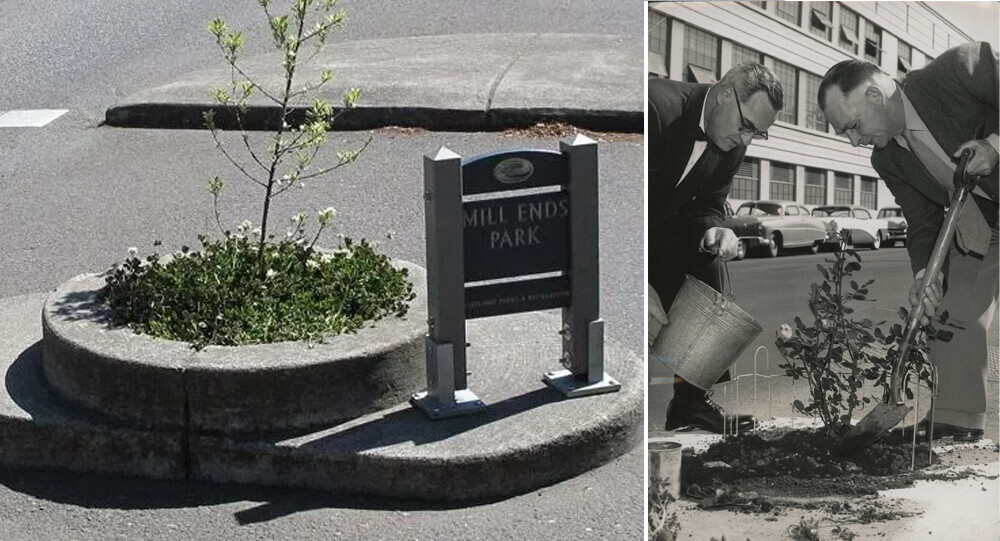
Mill Ends Park, the Smallest Park in the World
Portland, Oregon is home to the tiniest park in the world, a two-foot-diameter circle. Mill End Park is the name of this park.

Coolest and unique international boarders you must see
Not only do borders define us, but they also determine who we are. Simple lines on the ground, either man-made or geological, distinguish one culture from the next.

Mystery SOLVED: blood Rain in India
The dissemination of spores of microalgae has been identified as the origin of the 'Blood Rain' phenomena, according to a new study by Indian and Austrian experts. Since 1896, reports of intermittent red-colored rain in portions of Kerala and Sri Lanka have been coming in. The most recent one occurred in 2013 over Kerala.
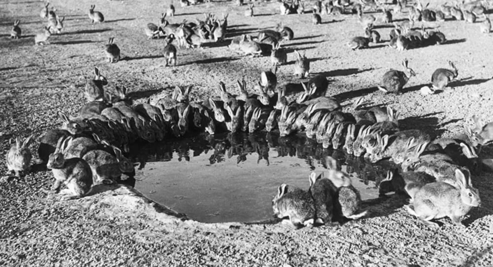
How European Rabbits Took over Australia
In 1859, wealthy settler Thomas Austin released 13 wild rabbits on his Australian estate. By 1920, their population grew to 10 billion.

The Tiny Street in Scotland That Holds the Record as the World’s Shortest
Nestled in the northern Scottish town of Wick, Ebenezer Place may be small, but it packs a world record punch. Measuring only 6 feet 9 inches (2.06 meters) long and boasting just a single address—the front door of Mackay’s Hotel—this narrow street has earned its place in the Guinness Book of World Records as the shortest street on the planet. Officially declared a street in 1887, Ebenezer Place delights visitors with its quirky charm and unique history that highlights how even the tiniest places can capture global attention.

The Benefits of Forest Bathing and Why It’s Gaining Popularity Worldwide
Forest bathing, or Shinrin-yoku, is an immersive practice of spending mindful time in natural forest environments, and it’s rapidly gaining global popularity due to its proven health benefits. From reducing stress and lowering blood pressure to boosting immunity and enhancing mental wellness, forest bathing offers a natural and accessible way to reconnect with nature and improve overall well-being. Explore the science, sensory experience, and rising trend behind this soothing practice.
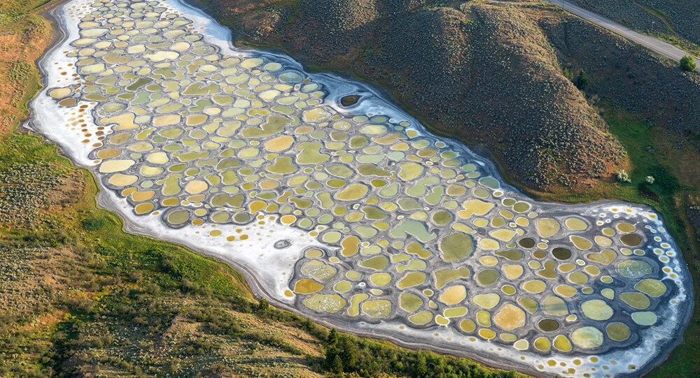
The Mystery of Canada's Magical Spotted Lake
Lake Khiluk, the world's most mineralized lake, and one of the most mysterious places on Earth. Each of these spots has a distinct chemical content and is said to cure various diseases.
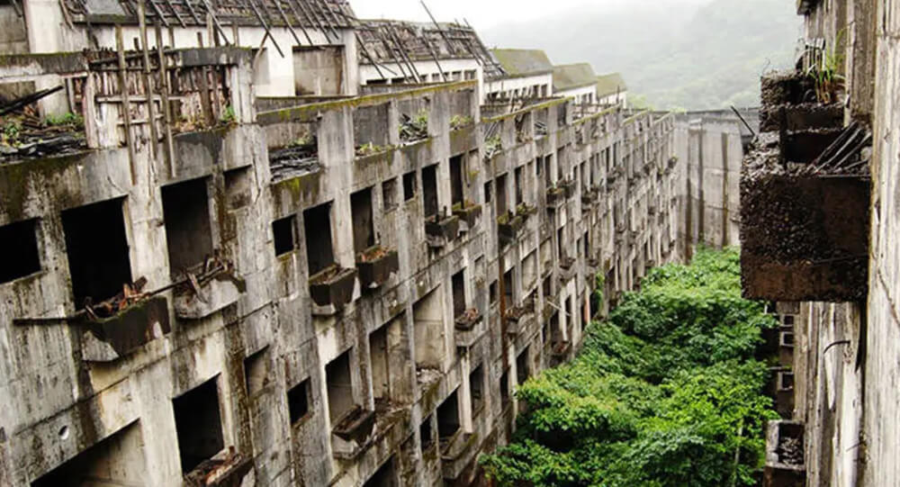
Famous abandoned cities and ghost towns in the world
Learn the stories behind seven of the world's most renowned abandoned cities and villages, from the infamous Chernobyl nuclear catastrophe zone to Hashima Island.
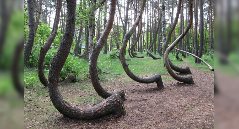
Poland's Krzywy: The Mysteries of the Crooked trees
In Poland, there is a forest with 400 crooked trees that have a 90-degree bend at the base of their trunks. Despite of numerous possibilities, the real reason and how it evolved remain a mystery.
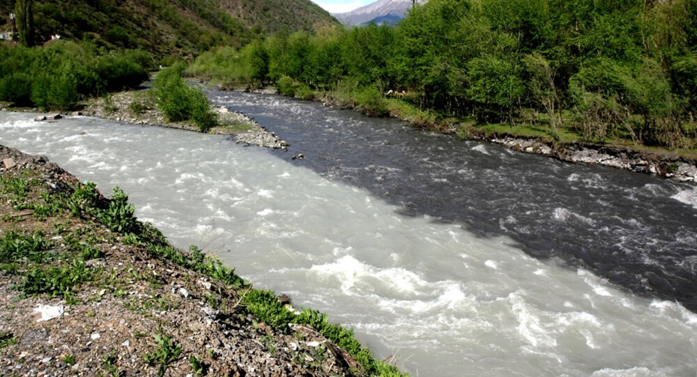
When two rivers meet but do not mix in Georgia
The incredible Black and White Aragvi river in Georgia that do not mix up.
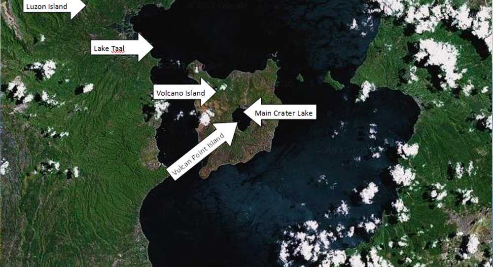
Taal volcano: The Island in a Lake on an Island in a Lake on an Island
Lake Taal, on the island of Luzon, in the Philippines archipelago's northernmost reaches, is unique. It's now one of just two lakes in the world with a third-order island within it, with the lake itself being a part of the order. In other words, Lake Taal, which is located on the island of Luzon, has a volcano (Volcano Island), a lake (Crater Lake), and its own little island (Vulcan Point).
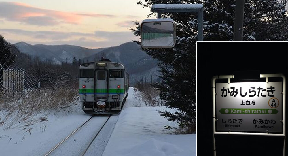
This soon-to-be-closed train station in Japan only serves one passenger
Japan keeps a defunc train station operational in 2015 for the sole purpose of allowing one girl to go to school every day. Only two stops are made by the train: once when an only one high school student departs for school and once when she returns.
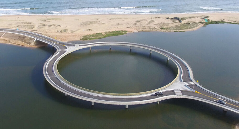
Circular Bridge Built To Slow Down Drivers So That They Would Enjoy The View (Photos)
Uruguay’s Laguna Garzon Bridge splits into a circle so drivers can slow down and enjoy the view. It also prevents head-on collisions and creates a walkway for pedestrians.
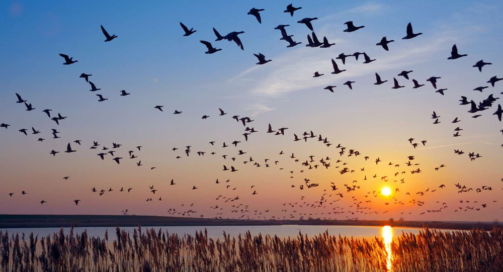
How Migratory Birds Navigate Thousands of Miles Without Getting Lost
Migratory birds undertake epic journeys spanning thousands of miles with astonishing precision, never losing their way. Their secret lies in a remarkable blend of innate senses, learned experience, and sophisticated navigation tools—ranging from the Earth's magnetic field to celestial clues and mental maps. Explore how these feathered travelers accomplish one of nature's most astounding feats through science, intuition, and adaptation.
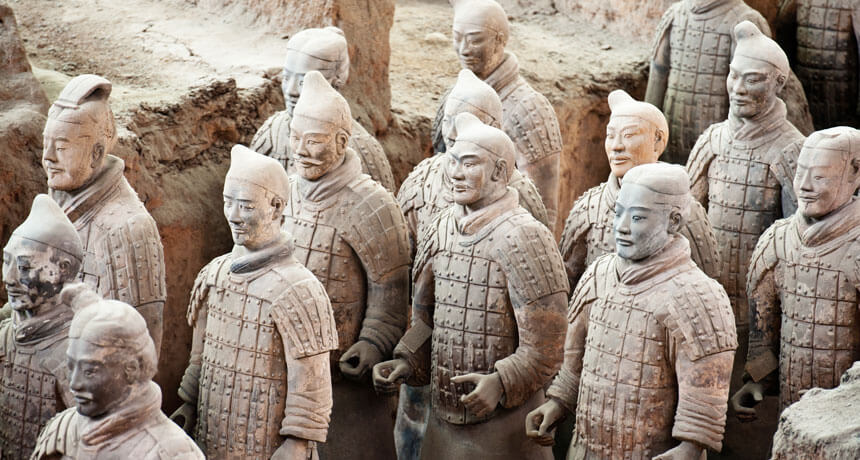
Top 10 Greatest and shocking Archaeological Discoveries of All Time
While we're all locked at home, there's no better way to escape to another time and place than to learn about amazing archeological sites and discoveries from around the world. Here are the 10 greatest and shocking archaeological discoveries —and don't be shocked if they inspire future trip plans whenever it's safe to do so again.
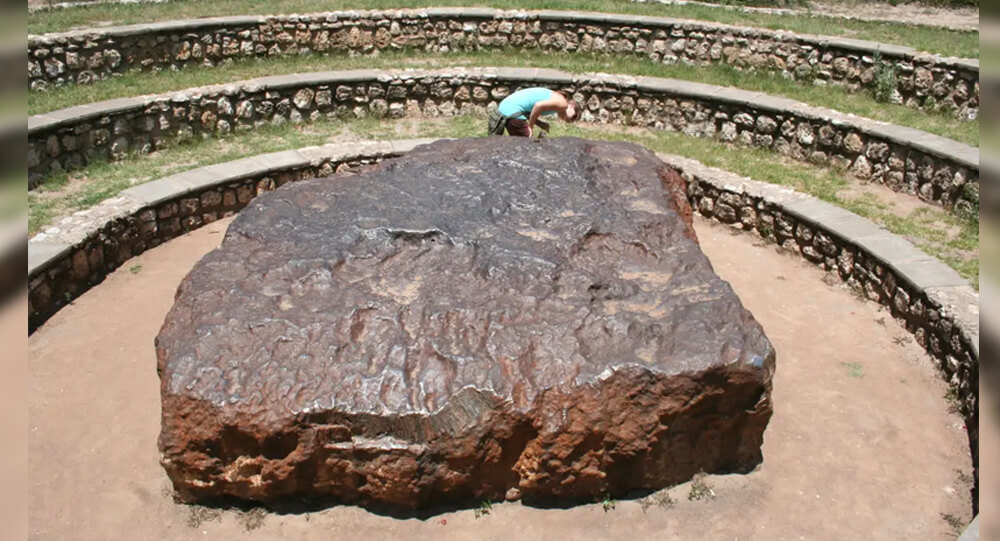
Top 6 Largest Meteorites Ever Found on Earth
When space meteorites hurtle towards Earth, they frequently burn up in the atmosphere before reaching us. Those that burn up become meteors - or shooting stars.
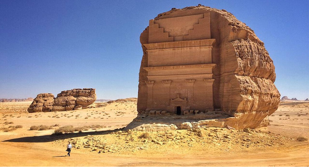
Qasr al-Farid, the Lonely Castle of the Nabataeans
The remote tomb of Qasr al-Farid, situated in the Saudi Arabian desert, dates back to the 1st Century CE. It was built by the Nabataean people, who also built Petra in Jordan. This site has remained largely undisturbed.
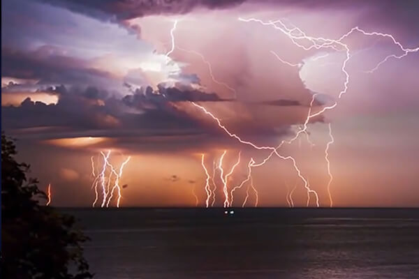
8 most amazing natural phenomena on earth
Nature is elusive and unpredictable, and the unexplained manifestations of its influence often leave us speechless. Though you might believe that shifting rocks and blood-colored rain are a prank or a magical phenomenon, science has an explanation for (almost) anything.
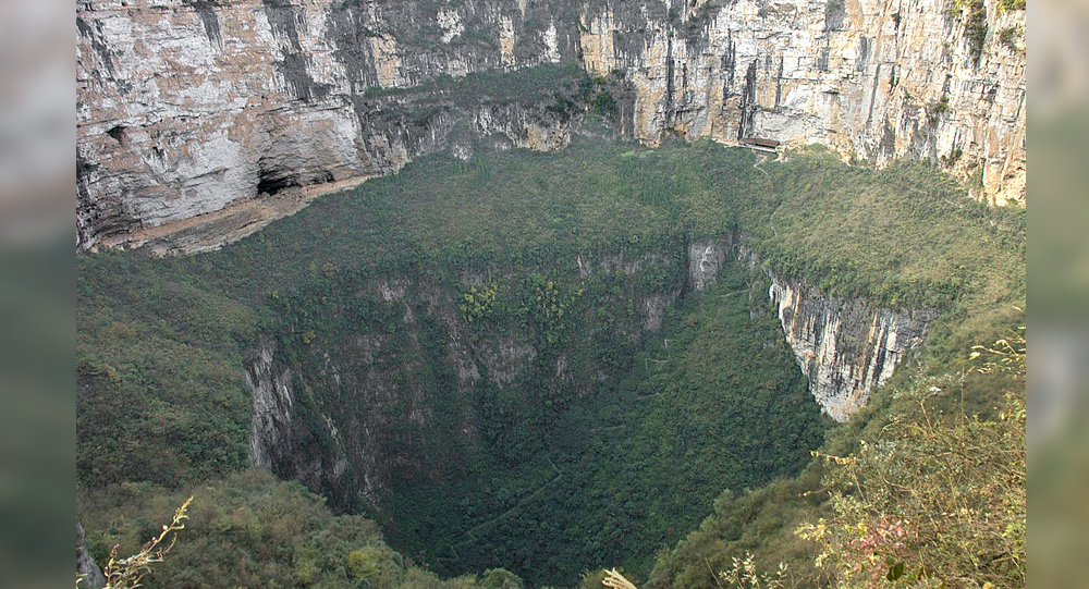
Xiaozhai Tiankeng: Exploring the World’s Deepest and Largest Natural Sinkhole
Hidden in the rugged terrain of Chongqing, China, lies Xiaozhai Tiankeng—the world’s deepest and largest natural sinkhole. Known as the “Heavenly Pit,” this colossal natural wonder plunges between 511 and 662 meters deep and stretches over 600 meters wide, dwarfing many familiar landmarks. This article journeys into the geological origins, unique ecosystem, and mysterious caverns beneath Xiaozhai Tiankeng, revealing a spectacular glimpse into Earth’s hidden landscapes.
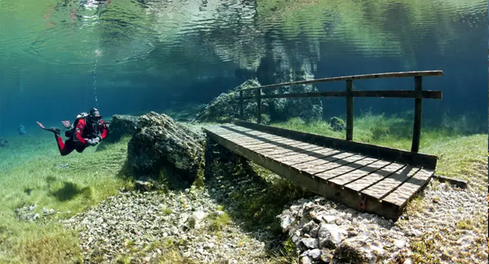
Grüner See, The Park That Turns Into A Giant Lake Naturally
There is a place in Austria called Grüner See which is a dry park in winter and turns into a 12-meter-deep lake in summer.
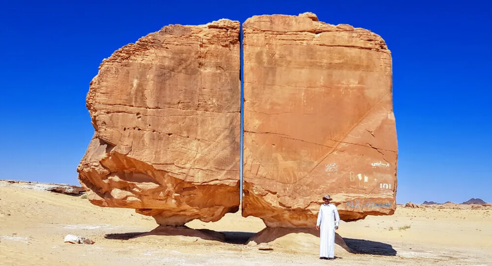
How Were the Two Parts of the Al Naslaa Rock Formation Created?
Scientists have been puzzled by the Al Naslaa rock formation in Saudi Arabia for a long time, and there is still no explanation for why this boulder appears to have a precise incision across the middle of it.
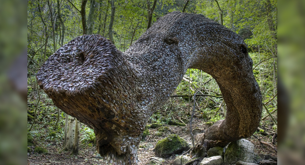
The Mystical Money Tree of the Scottish Highlands: A 1,700-Year-Old Tradition
In the Peak District Forest of the Scottish Highlands in the UK, there is a unique tree which is laden with only money. This tree laden with money has been studded with British coins for 1700 years, there is no corner of its trunk where a British coin is not stuck.
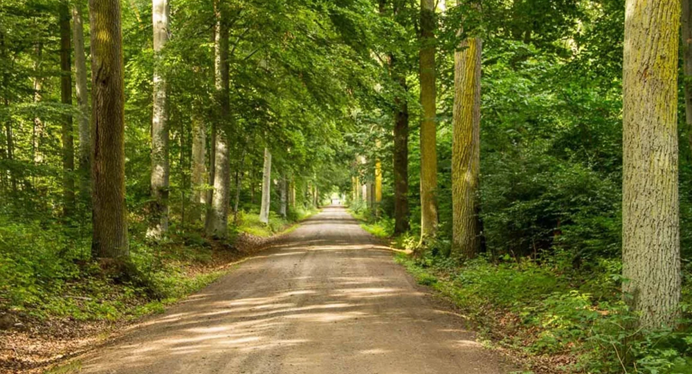
How Sweden’s 300,000 Oak Trees Became an Unintended Legacy: The Naval Forest That Outlived Wooden Warships
In the 1830s, Sweden planted 300,000 oak trees for the purpose of building naval ships. However, by the time the trees matured, metal warships had replaced the need for wooden ones. The forest still stands to this day.
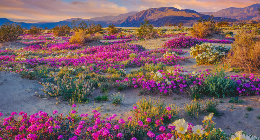
The Desert That Turns Into a Garden of Flowers Every Few Years
In parts of the desert where life seems most scarce, nature orchestrates an extraordinary transformation: the barren ground bursts into vibrant colors as wildflowers bloom after rare periods of rain. This phenomenon, known as a desert superbloom, is both awe-inspiring and scientifically fascinating. Learn how deserts like the Sonoran transform from arid landscapes into stunning floral displays, the environmental triggers behind this spectacle, and what these blooms reveal about resilience and adaptation in extreme environments.