Sandy Island: The Phantom Island That Fooled Maps and Google Earth for Centuries
For more than a century, Sandy Island was a mysterious fixture on maps, atlases, and even Google Earth. Charted as early as 1774 and reported by whalers and explorers throughout the 19th century, this supposed island in the Coral Sea, northwest of New Caledonia, was believed to be as large as Manhattan. Yet, in 2012, a team of scientists sailed to its coordinates and found nothing but deep blue ocean—a revelation that officially “undiscovered” one of the world’s most persistent cartographic myths.
A Cartographic Mystery Spanning Centuries
Sandy Island’s story began with early explorers and whalers, such as the crew of the ship Velocity, who reported its existence in the late 1800s. It was subsequently included in British Admiralty charts and major atlases, with some sources describing it as 15 miles long and 3 miles wide. The island’s presence persisted through the transition from paper maps to digital databases, even appearing as a black polygon on Google Earth well into the 21st century.
The 2012 “Undiscovery” Expedition
The legend of Sandy Island unraveled in November 2012, when a team of Australian geologists from the University of Sydney set sail aboard the research vessel Southern Surveyor. Their mission: to study plate tectonics, but curiosity led them to the coordinates of the infamous island. As they approached, the team expected to see land on the horizon. Instead, they found only open water. Depth-sounding equipment confirmed the ocean floor was over 4,600 feet (1,400 meters) deep—far too deep for any island to exist.
The scientists double-checked satellite images, GPS data, and historical records. Everything matched—except for the missing island. The team’s findings were quickly reported, and Sandy Island was removed from Google Maps and other databases within days.
How Did Sandy Island End Up on Maps?
The persistence of Sandy Island was likely due to a combination of human error and natural phenomena. In the 19th century, cartographers often relied on secondhand reports from sailors and explorers, making mistakes inevitable4. One leading theory suggests that the original sightings may have been of a massive pumice raft—a floating mass of volcanic rock that can stretch for miles and appear island-like from a distance. The Coral Sea sits along a “pumice raft superhighway,” making such a misidentification plausible.
As maps were digitized, the error became entrenched in widely used databases, including those maintained by the U.S. military and referenced by Google Earth. This digital propagation ensured Sandy Island’s phantom status persisted into the modern era.
Fun Facts and Trivia
- Sandy Island appeared on maps for over 200 years, despite never existing as land.
- It was believed to be larger than Manhattan, measuring up to 15 miles long.
- The island was officially “undiscovered” in 2012, when scientists found only deep ocean at its coordinates.
- A likely explanation for the original sightings is a giant pumice raft, not actual land.
- After its debunking, Sandy Island was swiftly removed from digital maps, but traces of its outline lingered in some satellite views.
- The story has inspired comparisons to TV mysteries like “Lost” and fueled conspiracy theories about mapmaking and secret islands.
Conclusion
Sandy Island’s tale is a fascinating reminder of how myths and mistakes can persist in our collective knowledge, even in the age of satellites and digital cartography. Its “undiscovery” is a testament to the importance of scientific verification and the enduring allure of the unknown. Today, Sandy Island stands as one of history’s most famous phantom islands—a cartographic ghost that fooled the world for centuries.

Recipient of suicide victim's heart kills himself 12 years later
In 1995, Sonny Graham received a transplanted heart from a suicide victim. He then committed suicide in the very same manner as the donor.

The birth or sign language in Nicaragua
When 50 deaf Nicaraguan children who did not know sign language were placed in the same classroom, they created their own sign language. Scientists are still researching the unique spontaneous appearance of language, as well as its own evolution and training of grammar.
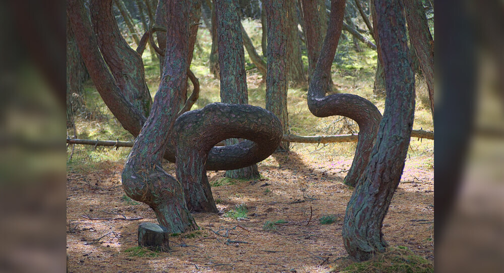
The Mystery of the Dancing Forest: Reasons behind the unusual wonders of forest
The Dancing Forest in Russia is noted for its unusually twisted pine trees. The trunks of these trees are contorted into spirals, rings, and other squiggly loops, but the reason for this malformation is still a mystery.

Poland's Krzywy: The Mysteries of the Crooked trees
In Poland, there is a forest with 400 crooked trees that have a 90-degree bend at the base of their trunks. Despite of numerous possibilities, the real reason and how it evolved remain a mystery.

Lucy and Maria The Biracial Twin Sisters with Rare Black and White Skin Colours
Lucy and Maria Aylmer are twins, but they have a hard time to convincing people. Even though they have mixed-raced parents, their mom was still shocked when the midwife handed her babies she’d expected to look alike, but were complete opposite.
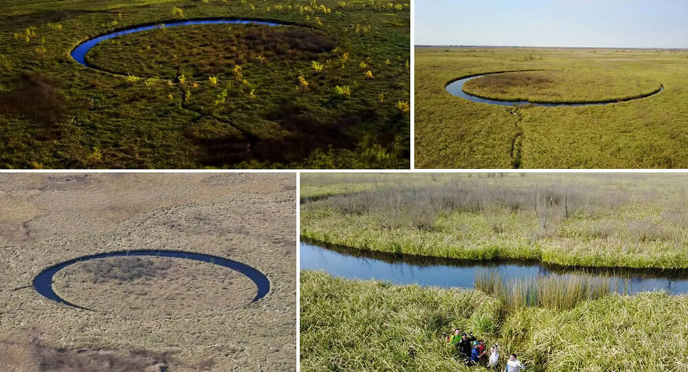
El Ojo, The Mysterious Rotating Island
In the middle of South America, a strange and nearly perfectly circle island moves on its own. The central landmass, known as 'El Ojo' or 'The Eye,' floats on a pond of clear and chilly water, looking strange and out of place in comparing to its surroundings. The bottom appears to be solid in compared to the marsh around it.
Top 10 Mysterious And Least Explored Places On Earth
Some people believe that there is nothing unexplored remaining on earth but the world doesn't cease to surprise us with its mysteries. Today I'll tell you about the lost places of the planet and animals that live only there.

The Unsolved mystery of Bobby Dunbar's Disappearance
In 1912, a four-year-old boy named Bobby Dunbar went missing on a family trip, 8 months later he was found and reunited with his family. Nearly a century later, DNA testing of his descendants revealed that the child reunited with the Dunbar family was not Bobby, but rather a boy named Charles (Bruce) Anderson who resembled Bobby.

Famous abandoned cities and ghost towns in the world
Learn the stories behind seven of the world's most renowned abandoned cities and villages, from the infamous Chernobyl nuclear catastrophe zone to Hashima Island.

The Remarkable story of jazz bassists Henry Grimes, lost but found as janitor and reclaimed the spotlight
Henry Grimes, one of the most versatile jazz bassists, disappeared in the 1960s and was later presumed dead. However, a jazz-loving social worker found him in 2002 working as a janitor in a hotel. Grimes found his way back into the limelight when a fellow musician sent him a bass as a gift. In 2016, he received a lifetime achievement award.

The 1978 Lufthansa Heist: Unraveling the Mystery of America's Most Infamous Airport Robbery
During the 1978 Lufthansa heist, robbers infiltrated JFK Airport, restraining employees and holding a night guard hostage. They escaped with $5.9 million—worth over $27 million today. The crime, linked to the Lucchese crime family, remained unsolved for decades, with most suspects vanishing
![[solved] “macaroni mystery”, 500 pounds of pasta dumped in new jersey](https://weeklyrecess.com/wp-content/uploads/2024/05/Macaroni-Mystery-cover.jpg)
[solved] “macaroni mystery”, 500 pounds of pasta dumped in new jersey
In April 2023, Old Bridge, New Jersey, faced a peculiar 'Macaroni Mystery' when 500 pounds of pasta were mysteriously dumped in the woods.
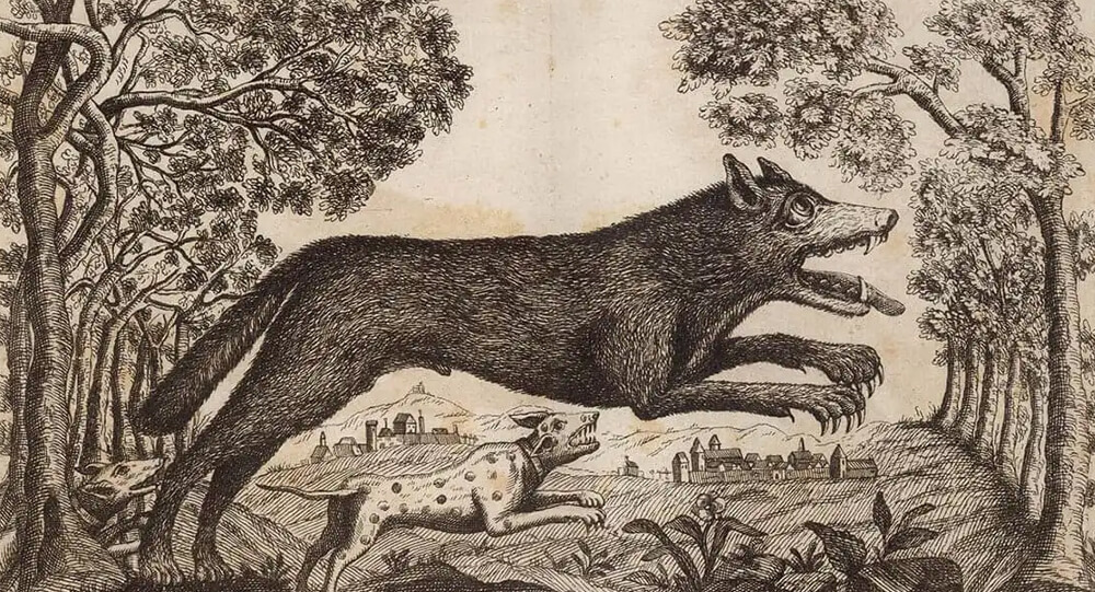
What Was the Beast of Gévaudan?
Between 1764 and 1767, a mysterious animal called the Beast of Gévaudan terrorized the French village called Gévaudan. It attacked and killed about 100 adults and children. While most believe it was a wolf, some say it may have been a wolf-dog hybrid, hyena or even a lion, but without any genetic evidence, the beast will remain a mystery forever.
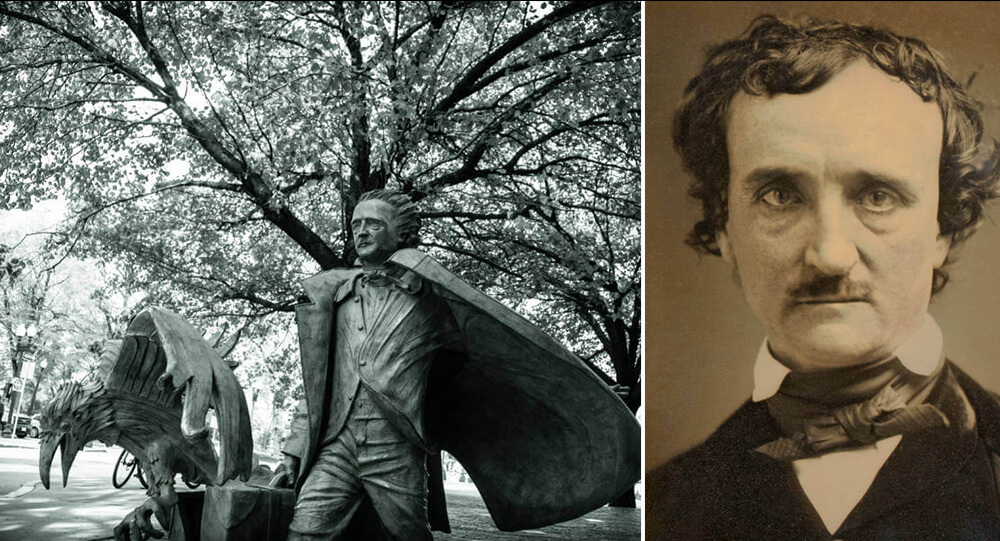
Inside The Mysterious Death Of The Famed Gothic Writer Edgar Allan Poe
Hours before his death Edgar Allen Poe was found on the streets of Baltimore. He was incoherent, wearing another man’s clothes, and unable to explain how he got there. The cause of his death is an unsolved mystery.
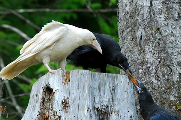
10 Rarest and Albino animals you haven’t seen
For centuries, people have been fascinated and enchanted by the ghostly appearances of abnormally white animals. People have loved albinos and other unusually white animals so much that they may be helping to increase their numbers, despite the difficulties these animals face in the wild. While these unusual animals did not win the genetic lottery, they have persevered in the face of adversity.
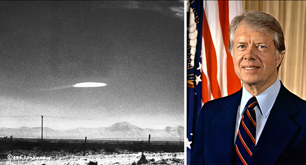
Jimmy Carter Once Promised to Release UFO Files—Here’s Why He Didn’t
During his 1976 presidential campaign, Jimmy Carter declared a bold intention: if elected, he would make all government UFO information available to the public. A man who openly admitted to having seen a UFO himself, Carter embodied a promise of transparency on one of the most controversial subjects of the Cold War era. However, once in office, Carter found powerful obstacles and, citing "national security concerns," chose not to release the files. This article unpacks Carter’s famous guarantee, the political realities he faced, and the enduring mystery surrounding government UFO secrecy.

The mystery of the Sri Lankan national handball team's disappearance
In 2004, the whole Sri Lankan national handball team disappeared. Later, the Sri Lankan government denied the existence of such a team. The location of the team is still unknown.
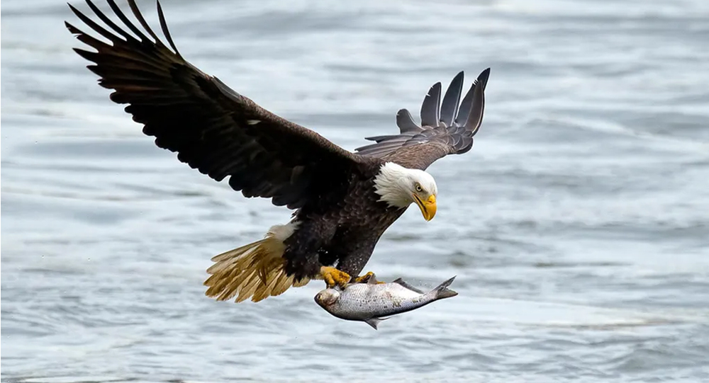
When the Sky Rained Fish: An Unbelievable Encounter Above Alaska
A small Alaskan plane was hit by a fish falling from the sky. It had been dropped by an eagle that misjudged its grip. The plane was unharmed, but it made the news as possibly the weirdest bird strike ever.
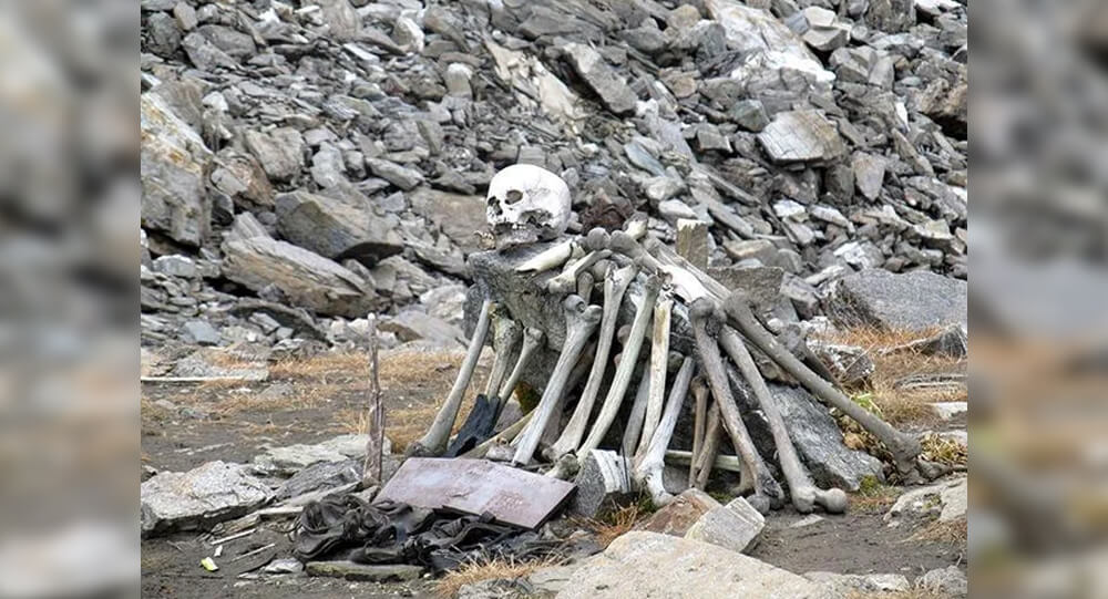
The mystery of India's 'lake of skeletons'
In 1942, a British forest guard in India made an alarming discovery. Some 16,000 feet above sea level, at the bottom of a small valley, was a frozen lake absolutely full of skeletons.

The mysterious Pumpkin impaled on the top of Tower
Twenty Three years ago, somebody impaled a 60-pound pumpkin 170 off the ground on this spire at Cornell University. Nobody knows who did this or how they did it.
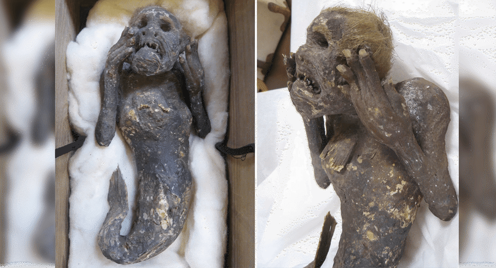
Mystery of 300-year-old mummified mermaid is being probed
There is a 300-year-old mummified mermaid with 30 centimetres tall and features a human-like head, two hands with what appear to be fingernails, and its lower body that look like a fish tail. The “mermaid mummy” is being probed by Japanese scientists in an attempt to unravel the mystery of its existence.
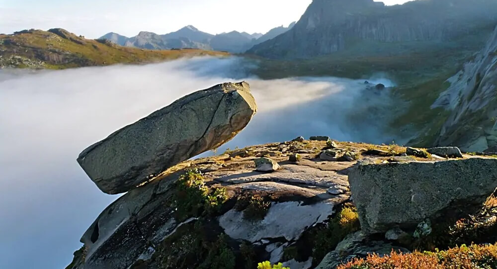
The Amazing Hanging Stone in Siberia Has Defied Gravity Since the Ice Age
The unbelievable "Hanging Stone" of Siberia weighs around 300 tons and has been hanging off a 1,000-meter cliff since the Ice Age.
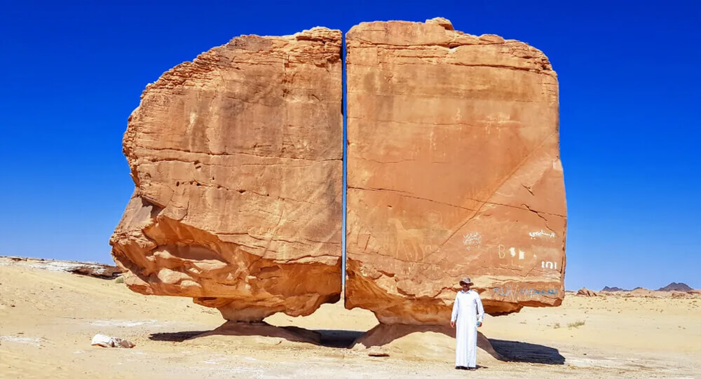
How Were the Two Parts of the Al Naslaa Rock Formation Created?
Scientists have been puzzled by the Al Naslaa rock formation in Saudi Arabia for a long time, and there is still no explanation for why this boulder appears to have a precise incision across the middle of it.

Lightning bolt restores man’s sight and hearing.
In 1980, an old blind and partially deaf man, Edwin Robinson, was struck by lightning. He suffered no injuries, but the impact of the lightning bold cured his vision and hearing.

The mysterious GIANT spherical stones
Mysterious spherical stones ranging in size from a few millimeters to several meters have been discovered in Crimea, United States, Russia, and New Zealand. There are many theories from various geologists, but none of them are clear.